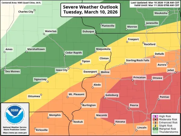

An updated severe weather outlook from the National Weather Service shows Galesburg and Knox County at enhanced to moderate risk Tuesday, with storms expected mainly between 3 p.m. and 2 a.m. The Galesburg area sits on the boundary between the enhanced and moderate risk zones on the latest outlook map.
Expected hazards include potentially strong tornadoes, scattered wind gusts over 70 mph, and hail larger than golf ball size. The Galesburg and Knox County area falls within the highest threat zone for tornadoes and large hail. Localized urban and small stream flooding is also possible.
Residents are encouraged to be ready to take shelter indoors when storms approach and to have a way to receive warnings overnight while asleep.
What the Knox County Sheriff’s Office is doing
The Knox County Sheriff’s Office is warning residents to closely monitor conditions and have a plan in place should warnings be issued.
Deputies will be positioned throughout Knox County this evening to assist with any weather-related emergencies, including road closures, storm debris, welfare checks, and coordination with fire and EMS agencies.
How to prepare
The Sheriff’s Office recommends residents take the following steps before severe weather arrives:
- Identify a safe shelter location in your home now — before storms arrive
- Charge phones and emergency devices
- Make sure you have multiple ways to receive weather alerts, including overnight
Residents can receive real-time weather alerts and emergency notifications through the Knox County Sheriff’s Office mobile app, available on the App Store and Google Play.
WGIL 93.7 FM and 1400 AM will continue to monitor conditions and provide updates throughout the evening.