
All of Illinois and much of the Midwest is preparing for the first severe storms of the season tonight.
Mike Albano, a meterologist with the National Weather Service Central Illinois office in Lincoln, joined WGIL's Tyler Gumm and Jay Redfern on Galesburg's Morning News to provide a forecast of the storms.
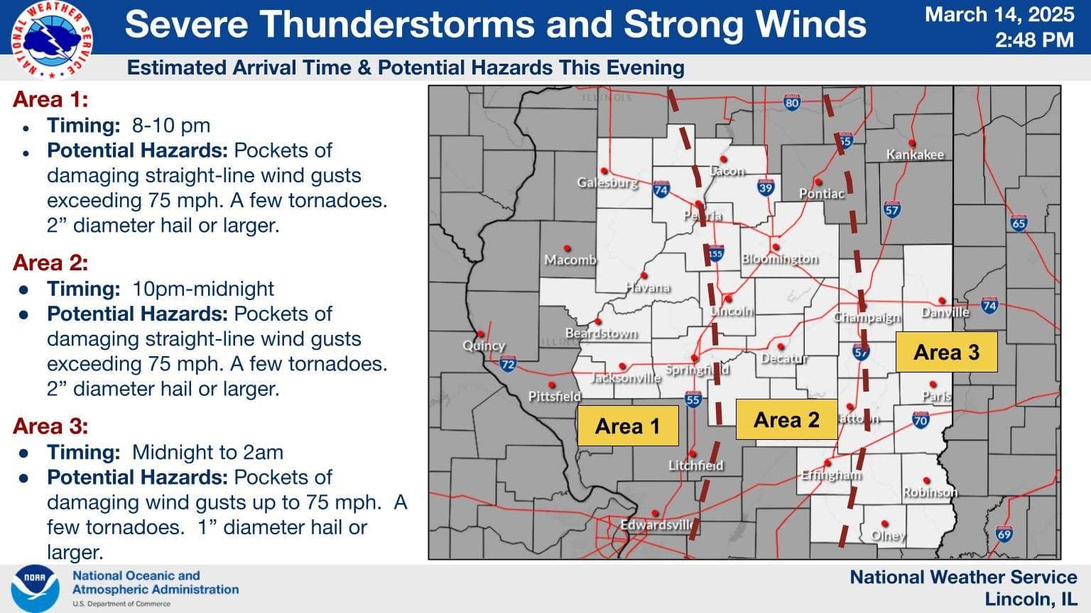
Imminent Severe Weather Threat:
- Central Illinois and much of the Midwest are bracing for the first severe storms of the season.
- The storms are expected to develop in central Iowa and Missouri early in the afternoon and move eastward.
Timing and Location of Impact:
- The Galesburg and Peoria areas are specifically at risk between 8 and 10 p.m. on Friday, March 14.
Severe Weather Hazards:
- Damaging Straight-Line Winds: Potential for winds in excess of 80 mph.
- Significant Tornadoes: Possible, particularly south of the Gailsburg area. A significant tornado is defined as EF2 or greater.
- Large Hail: Expected, with sizes ranging from 1 to 2 inches.
Characteristics of the Storms:
- Fast-Moving: The storms will be characterized by a robust wind field, with high winds even a short distance above the ground (90-100 mph at 500-1000 feet). This momentum can be transported downward.
- Not a Classic "Derecho": While strong winds are expected, the lack of significant atmospheric instability means this event is unlikely to be a widespread derecho like those seen in the summer.
- Instead, localized "pockets" of damaging winds are more probable.
Confidence and Uncertainty:
- Weather models have shown "stunning consistency" over the past several days, leading to high confidence that damaging thunderstorms will occur.
- The main uncertainty remains the coverage of the severe weather – whether it will be isolated pockets or a more widespread impact from the Quad Cities to St. Louis.
Expected Impacts:
- Tree damage is expected.
- There is a concern for potential structural damage due to the strong winds and possibility of tornadoes.
Watch and Warning Information:
- The NWS in Lincoln will be coordinating with the Storm Prediction Center to issue severe weather watches.
- A watch could potentially be issued as early as 3-5 p.m. on Friday, March 14, approximately 3-4 hours before the expected arrival of the storms.
Recommendations:
- Monitor local news, including WGIL, and weather reports for the latest updates and potential watch/warning issuances.
- Review and implement severe weather safety plans, including identifying a safe place to shelter (e.g., a basement or interior room).
- Secure any loose outdoor items that could be damaged or become projectiles in strong winds or hail.